Excavations at Duffus Castle, Moray
John Cannel & Christopher
Tabraham
ABSTRACT
In
1984 and 1985, limited excavations were carried out in the north-east corner of the
bailey, before and after emergency works to stabilize a leaning portion of curtain wall.
The excavations, though small in scale, produced clear evidence .for a primary occupation
in the 12th century, and for a substantial masonry-building phase in the 14th and 15th
centuries, thus going some way to confirming the evidence, from architectural and
documentary sources. The excavations were
funded by Historic Scotland.
INTRODUCTION
Duffus Castle
passed into State care in 1926 and immediately thereafter major consolidation works were
carried out on the upstanding masonry, including the stretches of curtain Wall encircling
the bailey. Towards the end of 1983, a large crack in the ground was observed immediately
uphill (that is, south) of the stretch of leaning curtain wall in the north-east corner of
the bailey (illus 1) Imminent collapse of the wall was feared and a decision was made by
the then Scottish Development Department (Ancient Monuments), now Historic Scotland, to
bring the wall back to the vertical position.
Temporary
scaffolding was erected in December i983 to shore up the leaning wall and a small
excavation was carried out in January 1984 on the uphill side of the wall (Trench F) in
the hope of locating the original position of the wall and thus enabling its accurate
reinstatement. In October 1985 a further small-scale excavation was carried out with two
aims: (a) to establish more clearly the function of the room of which the 'leaning' wall
formed the north side (Trench A); and (b) to determine more precisely the alignment and
nature of the missing curtain wall at the northeast corner of the bailey (Trenches B-E).
SHORT HISTORY
AND DESCRIPTION OF THE CASTLE
Duffus Castle (illus 2) served as a fortress-residence for over 500 years, from the 12th to the 17th century. During that time the place underwent great changes, none more radical than the replacement of the original earthwork-and-timber castle by one of stone and lime. When the first castle was built about AD 1150, it was among the foremost defensible strongholds in Scotland. By the time of
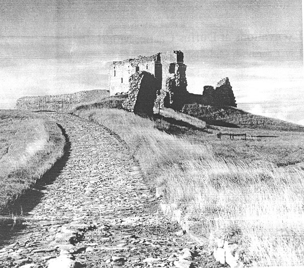
Illus 1 Duffus Castle, viewed from the stone bridge over the outer moat, to the north-east. The
excavations confirmed the documentary evidence that the castle earthworks originated in
the 12th century and that the masonry elements developed in the 14th century. The metal-
led road, the bridge, and the outer moat date probably no earlier than the 16th century.
its
abandonment, probably by the death of the 2nd Lord Duffus in 1705, the castle was little
more than a decaying fragment, completely unsuited as a residence of nobility (MacGibbon
8,: Ross 1887, 278 80; Cruden 1981, 125-6).
THE FIRST
CASTLE
The ancient province of Moray, which stretched from the River Spey on the east to Skye in the west, was a major region of the Pictish confederation. At the outset of the 12th century the province was governed by a 'mormaer' or Celtic Earl, Angus, grandson of
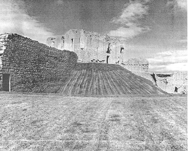
Illus 2 The great motte from the south, as seen from the bailey
Lulach Macgillecomgan, who had stepped into the shoes of the murdered Macbeth as King
of Scots in 1057. Fiercely independent and deeply suspicious of the growth of the national
monarchy, Angus rose up in revolt in 1130. The rising was firmly put down by David I, the
Earl was deposed and his Earldom taken into royal hands. King David immediately began to
settle the province with men of his own choosing, landlords whom he could trust to
preserve 'the King's peace'.
Perhaps the
most important newcomer was Freskin, a Flemish soldier of fortune already in possession of
an extensive estate in Lothian (Strathbrock, now Uphall). He was encouraged to come north
and settle in the lands of Duffus (Barrow 1973, 282). His son, William, adopted the title
'de Moravia' ('of Moray'), and by 1200 Freskin's descendants had become the most
influential family in northern Scotland, with kinsmen settled throughout Strathspey and
across the Moray Firth (Balfour Paul 1911, iii, 318-23).
It was most
probably Freskin who built the great earthwork-and-timber castle, a motte-and-bailey,
which so impresses visitors today. The motte is a massive mound, entirely man-made, with
steep sides and a wide, deep ditch encircling the base. Upon its flat top would have stood
timber buildings, further protected by a wooden palisade drawn around the edge of the
summit. The motte was reached from the bailey, a broad expanse of ground raised above the
surrounding land though not as high as the motte, either by a bridge carried over the
ditch or by steps climbing the mound. Here were the ancillary halls, lodgings and service
offices, such as the brewhouse, bakehouse, stables, workshops, and perhaps a chapel, all
necessary to maintain the household. Sadly, none of these structures has survived.
THE CASTLE
REBUILT
About 1270
the direct line of Freskin ended in two heiresses, One of whom married Sir Reginald Cheyne
the younger. For a time the Cheynes became the castle's new owners. But by about 1350 the
last Cheyne, Lord of Duffus, had died, leaving the estate to another heiress who married
Nicholas, second son of the 4th Earl of Sutherland. The Sutherlands remained in possession
until 1705 (Balfour Paul 1906, iii, 191).
We cannot say
with confidence who gave the instruction to rebuild the old timber castle in stone in the
14th century. Neither the architectural detail nor the documentary record is sufficiently
explicit for us to be sure. A reference from the year 1305 recording a grant to Reginald
Cheyne of 200 oaks from the royal forests of Darnaway and Longmorn 'to build his manor of
Dufhous' (Bain 1888, 375 and quoted in Cruden 1981, 126) indicates a major rebuilding
programme underway at that time and it may be that the wood was needed for flooring and
other parts of the emerging stone castle. We know that Cheyne's estate had suffered quite
considerable damage during the Wars of Independence with England, then at its height, and
it is possible that Reginald Cheyne was putting to rights war damage and taking the
opportunity thus presented of building a more impregnable castle of stone.
In :he new
castle the motte continued to support the main residence, a two-story rectangular tower
presumably with an embattled parapet at the wall top. The lord's hail was on the first
floor, with a latrine and small chambers, possibly used as bed-closets, off it. The ground
floor may have been used for storage as well as accommodation for the lord's household.
The tower was
designed with defence firmly in mind. The windows are small and sparsely set. The one
entrance into the ground floor has been protected by a portcullis. Doors at either end of
this front wall gave access from the first floor directly onto the wall-walk of the
curtain wall.
That curtain
wall, punctured by four gateways (three of which survive), completely enclosed the bailey.
There may have been quite a cluster of buildings within it, as the numerous put-log holes
in the curtain wall show. All have now gone. Along the north side, however, are the
vestiges of a stone range that, in its day, was impressive. It began life as an outer or
great hall, a reception room less restricted than that in the main tower, with a kitchen
at one end (confirmed by excavation) and a more intimate withdrawing room, the great
chamber, at the other. This building may have been erected after the Sutherlands became
lords of Duffus.
The
injudicious building of a stone castle upon the old earthworks is self-evident. Quite when
the walls started failing is uncertain, but repairs were carried out on certain subsidence
fractures before a greater part of the tower slid down the slope. The tower itself shows
no sign of later modification and may have been abandoned quite early on. The stone hall
block in the bailey appears then to have become the main residence, with alterations and
additions carried out to convert it into a modestly impressive laird's house. The ditch
encircling the motte was abandoned at the same time.
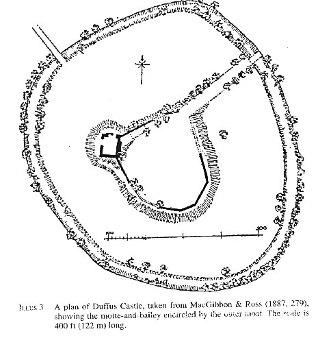
The date when the outer moat and the masonry bridge across it were built is uncertain. It is very difficult to see the moat (illus 3) as a defensive feature of the medieval castle and it seems more plausible to view its construction as part of the improvements to the castle grounds carried out in the later 16th and 17th centuries, in the twilight years of the castle's occupation. These improvements
are known to
have included an impressive orchard in the area between the motte-and-bailey earthworks
and the outer moat (OSA 1793, 395).
It was
probably in the remodelled hall block, not in the main tower, that Claverhouse dined as a
guest of Lord Duffus during his lightning campaign that ended at Ki!liecrankie in 1689. An
elderly woman, alive in 1760, recalled working at the castle as a girl and remembered
bringing the claret to the table during that dinner, probably one of the last occasions
the old castle was used (Shaw & Gordon 1882, 83-4). When the 2nd Lord Duffus built a
new residence, Duffus House, a short distance away, in about 1700, the castle fell rapidly
into decay.
THE
EXCAVATIONS
The
excavations (illus 4 & 5) were small in scale and little sense could be made of most
of the features found. Interpretation was further hampered by two other factors: first,
the extent of the ground disturbance carried out by the Office of Works in the late 1920s
as part of its operations to stabilize the upstanding masonry (most noticeable in Trench
E) and, secondly, by the limitations imposed by the scaffolding and safety considerations
in the vicinity of the 'leaning' wall in Trench
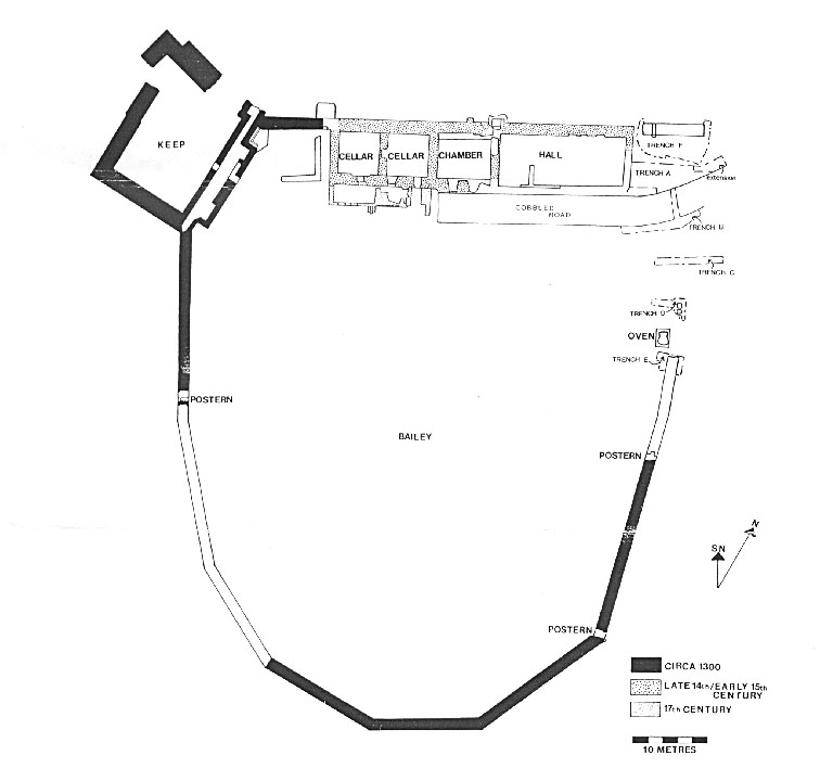
Illus 4 The masonry elements of Duffus Castle, showing the location of the trenches
PHASE I (
12TH/I 3TH CENTURY)
This first
phase, examined only in Trenches A and C, was clearly distinguished from later phases by
being sealed beneath a thick deposit of firm, mottled yellow/green clay. The phase was
dated to the later 12th/early 13th century by shards of straight-sided cooking pots (illus
6, nos 3, 5 & 6).
Phase 1
deposits survived patchily over much of Trench A, though it was possible to have only a
brief look at the full sequence of pre-14th-century activity in a small sondage in the
southwest corner of that trench.
In the
sondage, pinkish clay, presumably natural, was reached c 1 m below the present ground
surface. Directly above this natural clay was a layer of silty loam containing a few small
pebbles and flecks of charcoal. This had all the appearance of a buried topsoil above the
freshly scarped surface of the bailey. Above this was a 100 mm thick mottled yellow/green
clay which seemed to be a deliberate dump, and from which an almost complete, but rather
squashed, bovine skull was recovered. Overlying the clay was an isolated lump of silty
loam reaching a maximum thickness of 400 mm.
Outwith the
sondage, and stratigraphically contemporary with the loam, was a thin, intermittent layer
of silt with signs of burning on its surface. The only features of note were three patches
of metalled surface at the east end of the trench.
The sequence
of deposits in Trench C was broadly comparable with that in Trench A. Apart from the fact
that the depth of the phase 1 deposits suggests a considerable period of occupation,
nothing more can be inferred.
PHASE 2 -
4TH-6TH CENTURY)
This phase
comprised deposits lying above the clay sealing layer referred to above. This clay layer,
recorded in Trenches A, C, D and F only, is interpreted as a preparation layer laid down
immediately prior to the building of the stone castle. The architectural and documentary
evidence suggests that this was some time in the first half of the 14th century. The phase
2 deposits covered the broad time-scale of the 14th-16th century, based on the pottery
evidence, and were not capable of being refined further.
Trenches A
& F (kitchen area)
Prior to
excavation, the existence of a slop-drain in the 'leaning' curtain wail suggested the
possibility that this area to the east of the great hall had been a service office, most
probably a kitchen. Excavation supported this observation.
The 'leaning'
wall and the wall to its west appeared to form the north and west walls of the kitchen.
Excavation confirmed that the west wall, despite being largely rebuilt by the Office of
Works in the 1920s, was genuine. A number of post-holes (14, 15, 16, 28 & 35) and
stake-holes (25, 26, 29 & 30) within the kitchen may have held scaffolding poles used
in the construction work.
The west wall had been built directly on top of the clay dump without any footings, though where it returned west to form the south wall of the great hall it had a shallow foundation of mortared rubble. This same rubble foundation protruded 100 mm beyond the east face of the wall.
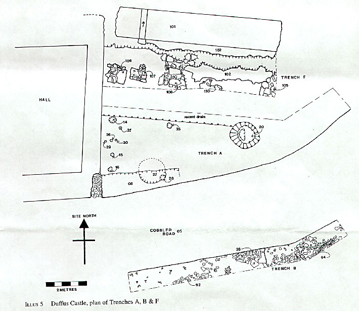
Continuing
east of this foundation and overlying one of the post-holes (28) was a shallow slot (08)
filled with small stones and sand. This was almost certainly the foundation for the south
wall of an extension east of the great hall. Although this extension was built later than
the great hall, because the foundation slot (08) overlay both the post-hole (28) and the
mortared foundation (06), it was undoubtedly planned at the same time.
The location
of the east wall of the kitchen was less apparent. Excavation produced three possible
candidates in Trench F. The first was a mass of rounded boulders (105) with just a hint of
a north/south face along its west edge. The second was a mortared stone feature (110). The
third was the remnant of a light north/south wall (108) consisting of two stones dressed
on their west faces and surrounded by loose rubble. The movement of the curtain wall had
destroyed the north part of this feature, and a later cut had removed its east face,
making its width indeterminable. Wall 108 seems the most probable of the three, for if its
line is extrapolated south it would meet up with the east end of foundation 08. This would
give a kitchen measuring 6.5 m north/south by 3 m east/west.
The interior
of the kitchen produced evidence for dense burning in the north half but none in the south
half, suggesting that the fireplace had been set against the curtain wall. This would
place the slop-drain in the back of the fireplace, a common enough location. Though the
north half was not excavated to any extent (the top surface was briefly cleaned and
recorded), two stone settings (106 and 107) were noted.
Excavation to
the east of the kitchen produced nothing further regarding built structures east of the
kitchen or indeed of the curtain wall itself. Instead it produced clear evidence for
demolition and clearance at a later medieval period. Almost all the clay sealing layer had
been removed by a large north/south cut. The cut formed an almost vertical edge 350 mm
deep. The reason for a major scarping can only be guessed at but it must post-date the
disuse of the kitchen. There were other features in the stony, silty loams that overlay
the cut, including a steep-sided circular pit (20), 1 m deep, whose function is unknown. A
shard of late medieval pottery came from its topmost fill.
Trench B
This small
trench revealed a patchy cobbled surface 500 mm below the present ground surface. The
cobbles were divided into three discrete patches: (a) a mixture of rounded stones (92)
rather loosely laid; (b) larger and more closely-laid cobbles (38) with a kerb of
sandstone slabs on the east; (c) a spread of rounded cobbles (94) loosely bedded and very
uneven. None of the cobble spreads was particularly worn. One of them, (38) was noticeably
better laid and it is possible that it represents a trackway pre-dating the 18th-century
one (see below).
There was no
sign of the east curtain wall in the trench.
Trench C
Other than
the clay sealing layer (52) mentioned above, little of any substance was noted. However,
several shards of pottery, including two with pie-crust decorated rims, recovered from the
layers directly above the clay sealing layer 52 may be dated to the early 14th century
(illus 6, nos. 1, 2 & 4).
Trench D
The opening
of this trench was prompted by the presence of three large squared boulders (46)
protruding above the turf. They lay approximately along the line of the projected east
curtain wall and it was hoped that they might produce further evidence for the 'missing'
curtain wall along this north-east side of the bailey.
The stones
lay directly on top of the clay sealing layer (called 47 in this trench but identical to
36, 52 and 103 in Trenches A, C and F respectively). They certainly appeared to be
foundation stones, but for a wall no more than 0.6 m wide, clearly insufficient for the
substantial width of a defensive curtain wall. (The 'leaning' wall in Trench F was 1.45 m
wide and its foundations had cut through the clay sealing layer 103, not laid on top.)
These stones are more likely to have formed part of a building enclosing the adjacent oven
structure which was consolidated and laid out in the 1920s. The phase 1 layers beneath the
clay seal were not excavated.
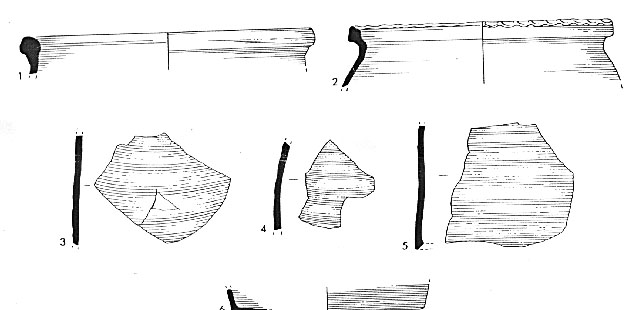
Illus 6 The pottery
Trench E
This small
trench confirmed the extensive underpinning of the upstanding stretch of the east curtain
wall carried out by the Office of Works in the 1920's. It also revealed a large
stone-lined pit adjoining the north-west corner of the wall. The precise shape of the pit
could not be ascertained but it probably measured c I m in diameter at the top, narrowing
to 0.7 m near the base. It was c 1.6 m deep. The pit had been completely cleared out in
the 1920s and no datable artifacts were recovered. The relationship between the pit and
the wall had been destroyed in the 1920s but the pit did not appear to post-date the wall
and the balance of opinion points to the pit and curtain wall being contemporary.
PHASE 3
(17TH-18TH CENTURY)
The evidence
for extensive demolition and clearance at the north-east corner of the bailey has been
noted above. Though not precise, a date late in the medieval period is suggested by the
pottery. By contrast, the present cobbled road that enters the bailey at the north-east
corner was closely dated by pottery. A basal shard, unbraided and unworn, from a Delftware
plate, made c 1750, Was recovered from the bedding sand, indicating that the road was
built in the third quarter of the 18th century.
CONCLUSIONS
The
excavations produced clear evidence for primary activity at the site in the later 12th
century, thus confirming the documented evidence linking the origin of the castle with the
arrival of Freskin of Strathbrock about AD 1150. The limited nature of the excavation
precluded any clearer picture emerging of the nature and appearance of that first
earthwork-and-timber castle.
The
excavations also produced evidence for a radical rebuilding of the castle in stone at some
stage in the 14th century. The earlier buildings in the bailey seem to have been removed
wholesale and the ground leveled by the dumping of a thick clay sealing layer. Thereafter
the masonry walls of the new castle were erected. The encircling curtain wall was founded
by cutting through the clay, but the other less substantial walls were laid directly on
top of the clay.
The
excavations have suggested that there was a kitchen, immediately to the east of the great
hall, measuring about 6.5 m by 3 m. No other structures were identified. At some later
stage major demolition and clearance works were undertaken in the north-east corner of the
bailey; so comprehensive were these that all trace of other structures, and most
critically the encircling curtain wall at this point, had been removed. The nature of the
gatehouse, which is likely to have been situated at this point, will never be known.
Although
these clearance works cannot be closely dated, it seems reasonable to link them with major
changes to the main residential accommodation referred to above. The creation of a modest
house (out of the shell of the great hall and chamber along the north side of the bailey)
to replace the accommodation lost with the collapse of the tower atop the motte, might
explain the abandonment of the kitchen. The apparent clearance of the north-east curtain
wall in the later medieval period is not so easily explained.
Finally, the
excavations produced evidence for the present cobbled road being laid in the third quarter
of the 18th century, after the abandonment of the castle as a noble residence. By
association this may also provide a date for the construction of the stone bridge crossing
the outer moat to the east, and for the creation of the moat itself. However, it is very
difficult to envisage such substantial works being carried out at this date. Any
landscaping improvements are more likely to have been carried out whilst the castle was
still inhabited. Perhaps the dating reflects a repair to the road, suggesting that the
grounds of the ruined castle were still being maintained as an attractive feature in the
landscape long after the castle had ceased to be. The anonymous contributor to the first
Statistical Account of Scotland (OSA !793, 395) certainly confirms the charm of the place
for the traveler:
Old Duffus is
surrounded with orchards and fruit trees, and, standing in the heart of
a charming plain, presents, at every point of view, one of the most picturesque and
beautiful objects which the country exhibits.
ACKNOWLEDGEMENTS
This report
was written in draft by John Cannel and edited by Christopher Tabraham, who organized the
excavations on behalf of the Inspectorate of Ancient Monuments (SDD) and who added the
section on the history and architecture and the conclusions. Both are indebted to Eoin
Cox, John Lewis and Alan Radley, who assisted at the excavations, and to George Haggarty
who advised on the pottery. Alan Radley also assisted in the preparation of this report
and of the archive, which has been lodged with the National Monuments Record of Scotland.
The pottery has been deposited in the National Museums of Scotland.
The
excavations were funded entirely by the Scottish Development Department (Ancient
Monuments), now Historic Scotland.
REFERENCES
Bain, J (ed)
1888 Calendar of Documents relating to Scotland, Vol IV. Edinburgh. Balfour Paul, J
1906 8,: 1911 The Scots Peerage. Edinburgh.
Barrow, GWS
1973 The Kingdom of the Scots. Edinburgh.
Cruden, S
1981 The Scottish Castle. Edinburgh.
MacGibbon, D
& Ross, T 1887 The Castellated and Domestic Architecture of Scotland, Vol 1.
Edinburgh. OSA 1793 The Statistical Account of Scotland. Edinburgh.
Shaw, L &
Gordon, J 1882 The History of the Province of Moray, vol 2. Edinburgh.
This paper is
published with the aid of a grant from Historic Scotland