 Elgin: Area 7
This page was copied from: http://www.suat.demon.co.uk/elgin_bs/elgin_a7.htm for informational and historical purposes. Please note original copyright at bottom of page. Duffuses had an early presence in Elgin.
Elgin: Area 7
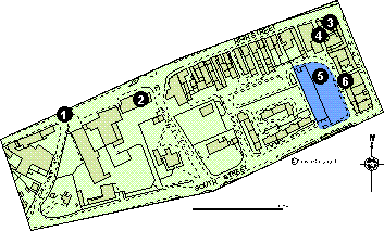
Defined by South Street to the south, High Street to the north, Batchen Street to the east and an arbitrary line to the west of West Park Road. It contains the sites of the West Port and of Thunderton House.
Click here for a full size map (31K)
This stood at the north eastern end of West Park Road until 1783 when it was illegally removed by the owner of a house called West Park (Simpson and Stevenson 1982, 19).
Trial excavations by T. Chilton in 1976 in advance of the relief road located natural sand at c 0.65 m.
Founded in the 14th century this was the site of `The Great Lodging' of the Scottish Kings. The present building dates to 16th/17th centuries but has been much altered (Simpson and Stevenson 1982, 9). In 1801 part of the eastern part of this structure was feued for the building of Batchen Street (McKean 1987,30).
A watching brief by SUAT in 1993 located natural sand at 0.55 m. Above this was a black grey silty sand containing Victorian pottery and glass. (Cachart 1993, 40).
Trial excavations by SUAT in 1986 in advance of a supermarket development located natural sand at 0.2 m. One large feature was located that produced no finds. (Hall 1986, 12).
A watching brief by SUAT in 1989 located a drystone built well apparently of post medieval date. (SUAT Archive report).
The limited work in this area suggests that the preservation of deposit gets worse as one moves south from the High Street. Again this is reflecting the topography, as the ground slopes up towards the south. On the limited information available it is possible that preservation on the south side of the High Street is better than it is on the north. As with Area 1, this part of the town may contain remains of the earlier burgh that was burnt down (Shaw 1827, 263).
Copyright © Scottish Urban
Archaeological Trust Limited
55 South Methven Street, PERTH, PH1 5NX
Tel: +44 (0)1738 622393
Fax: +44 (0)1738 631626
E-Mail: derekh@suat.demon.co.uk