 Elgin: Area 3
This page was copied from: http://www.suat.demon.co.uk/elgin_bs/elgin_a3.htm for informational and historical purposes. Please note original copyright at bottom of page. Duffuses had an early presence in Elgin.
Elgin: Area 3
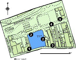
Defined by High Street to the south, the relief road (Alexandra Road) to the north, North Street to the west and Lossie Wynd to the east.
Click here for a full size map (24K)
A watching brief in 1988 located two wooden planks 7 m west of Forsyth Close. (Shepherd 1989, 24).
Excavations in 1988 by SUAT in advance of the construction of the St Giles centre took place on these two sites. Two trenches were opened behind 115 High Street in the tarmac car park. In Trench 1, c 0.70 m of deposit was located sealing features cut into the natural sand. Two of the pits excavated produced a small assemblage of medieval pottery of 12th/13th century date. Structural remains were located sealing these pits, represented by a clay bonded stone wall, a linear trench and several postholes. These were sealed by a pebbled close which was then sealed by the remains of a stone building and another close built of stone setts.
A single trench was opened behind 121 High Street and several cut features were located in the natural sand; one of these may have been a badly damaged tanning pit. On the western side of the site, c 0.50 m of organic midden was located beneath a former close line. Two small sherds of Stamford ware were recovered from this midden. (Hall 1989, 24).
A watching brief in 1987 by SUAT located natural sand directly below the foundations of the 17th century townhouse. (Hall 1987, 23).
Trial excavations in 1976 by W. J. Lindsay in advance of the relief road located natural sand at c 0.60 m.
Trial excavations in 1987 by SUAT in advance of the construction of the St Giles Centre located natural sand c 0.61 m below modern ground level. A few sherds of medieval pottery were recovered from the garden soil. (Hall 1987, 23).
The excavations in advance of the St Giles Centre (no 2) largely confirmed that preservation on the High Street frontage is very poor but that deposits will survive from c 20 m north of the frontage. These deposits are anaerobic, so there is a strong chance of the survival of organic remains. Preservation under former close lines in this area will also be fairly good. This is confirmed by the watching brief at Forsyth's Close (no 1). Nos 4 and 5 tend to suggest that deposit survival begins to tail off again towards the northern limits of the burgh. The same appears to be suggested by nos 1 and 2 in Area 2.
Copyright © Scottish Urban
Archaeological Trust Limited
55 South Methven Street, PERTH, PH1 5NX
Tel: +44 (0)1738 622393
Fax: +44 (0)1738 631626
E-Mail: derekh@suat.demon.co.uk